PRELIMINARY CONCEPTS:
1. When warmed, air rises because it becomes less dense ("lighter").
2. When warm air rises, a low pressure area is created where it left.
3. When it reaches higher altitude, warm air cools down, condenses and forms clouds.
1. When warmed, air rises because it becomes less dense ("lighter").
2. When warm air rises, a low pressure area is created where it left.
3. When it reaches higher altitude, warm air cools down, condenses and forms clouds.
 Figure 1: TC in the Northern Hemisphere | 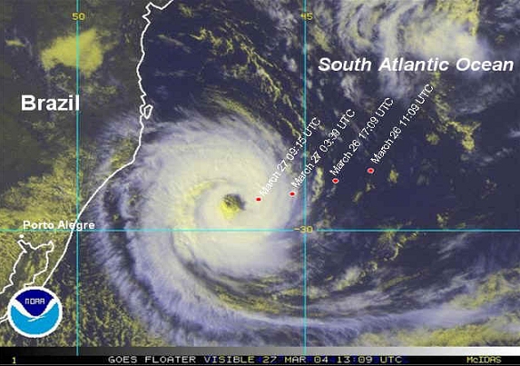 Figure 2: TC in the Southern Hemisphere |
 Figure 3: Global tracks & intensity of Tropical Cyclones, which shows the Philippines under very high risk for intense tropical cyclones (e.g. Super Typhoons). Image Credit: NASA.
 Tropical cyclone (known as “Bagyo” in the Philippines) is the global generic term for an intense circulating weather system over tropical seas and oceans. It is accompanied with very strong winds, heavy rains & large ocean waves. Its wind circulation rotates Counter-clockwise in the Northern Hemisphere (see Fig. 1) & Clockwise in the Southern Hemisphere (see Fig. 2).
On the average, 100 Tropical Cyclones form in the world annually, where two-thirds become typhoons and hurricanes. Western North Pacific Ocean (includes the South China & Philippine Seas) holds the highest place of formation (30%), followed by the East Pacific Ocean (15%), Western Atlantic Ocean-South & North Indian Oceans-South Pacific Ocean (12%), Northern and Western Australia (7%). (see Fig. 3).
How Do Tropical Cyclones Form?
There are a couple of ingredients that will benefit for the formation of a Tropical Cyclone here in the Philippine Sea and Western Pacific Ocean (see Fig. 5). These are:
- Warm Sea Surface Temperature (SST) of at least 26.5°C with a depth of 150 feet & high moisture/ humidity present in the atmosphere. The heat from the sea is therefore the main energy source for Tropical Cyclones.
- Presence of the Intertropical Convergence Zone (ITCZ). The ITCZ plays an important role in the formation of Tropical Cyclones as it delivers convergence of Northeasterly & Southeasterly or Southwesterly Trade winds. Its convergence will trigger a rotation of low-level winds which then develop into Tropical Cyclones - if other ingredients are present (see Fig. 6).
- Existence of Tropical Disturbances (aka. Low Pressure Areas or LPAs) within the ITCZ. When the ITCZ is very active, multiple tropical disturbances occur and it aids for development of Tropical Cyclones (see Fig. 7).
- Weak vertical wind shear or light winds in the upper atmosphere. If wind speeds in the upper atmosphere (20-50,000 feet ASL) are low (<20 km/hr), a TC can develop rapidly usually within 1 to 2 days.
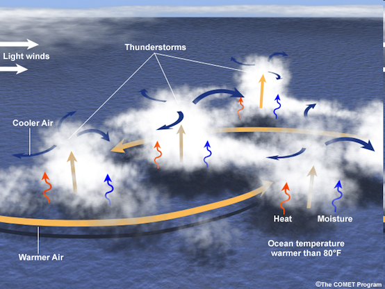
Figure 5: The ingredients needed for the development of Tropical Cyclones. Graphic Credit: MetEdu/COMET Program
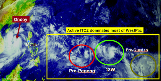
Figure 6: Strong ITCZ dominating the Western Pacific Ocean, showing the formation of three tropical cyclones as the Killer Ondoy moves west. This image was taken in September 27, 2009. Image Credit: MTSAT. Illustration by: David Michael V. Padua
Death & Dissipation of Tropical Cyclones
Tropical Cyclones die when:
Tropical Cyclone Classification
The new storm warning signal classifications system is as follows:
Aside from the revised storm warning system, the classifications of tropical cyclone has also been modified.
Below are the classifications of tropical cyclones according to the strength of the associated maximum sustained winds:
Typhoons that develop east of the Dateline and up to the Western Atlantic Ocean are called Hurricanes. Meanwhile, typhoons in other basins like the Bay of Bengal, North & South Indian Oceans, South Pacific Ocean, and the seas over Northern & Western Australia are called Cyclones.
Tropical Cyclones die when:
- They enter an environment of cool dry air and leave the environment of warm, moist tropical air.
- They move over a large land mass.
- When they travel over cooler sea surface temperatures (SSTs) or under unfavorable large scale circulation of air currents at high levels in the earth’s atmosphere (eg. strong vertical wind shear).
Tropical Cyclone Classification
The new storm warning signal classifications system is as follows:
- PSWS No. 1: tropical cyclone winds of 30 to 60 kph are expected within the next 24 hours
- PSWS No. 2: tropical cyclone winds of 61 to 120 kph are expected within the next 24 hours
- PSWS No. 3: tropical cyclone winds of 121 to 170 kph are expected within the next 18 hours
- PSWS No. 4: tropical cyclone winds of 171 to 220 kph are expected within the next 12 hours
- PSWS No. 5: tropical cyclone winds of more than 220 kph are expected within 12 hours
Aside from the revised storm warning system, the classifications of tropical cyclone has also been modified.
Below are the classifications of tropical cyclones according to the strength of the associated maximum sustained winds:
- Tropical Depression (TD): up to 61 kph
- Tropical Storm (TS): 62 to 88 kph
- Severe Tropical Storm (STS): 89 to 117 kph
- Typhoon (TY): 118 to 220 kph
- Super Typhoon (STY): exceeding 220 kph
Typhoons that develop east of the Dateline and up to the Western Atlantic Ocean are called Hurricanes. Meanwhile, typhoons in other basins like the Bay of Bengal, North & South Indian Oceans, South Pacific Ocean, and the seas over Northern & Western Australia are called Cyclones.
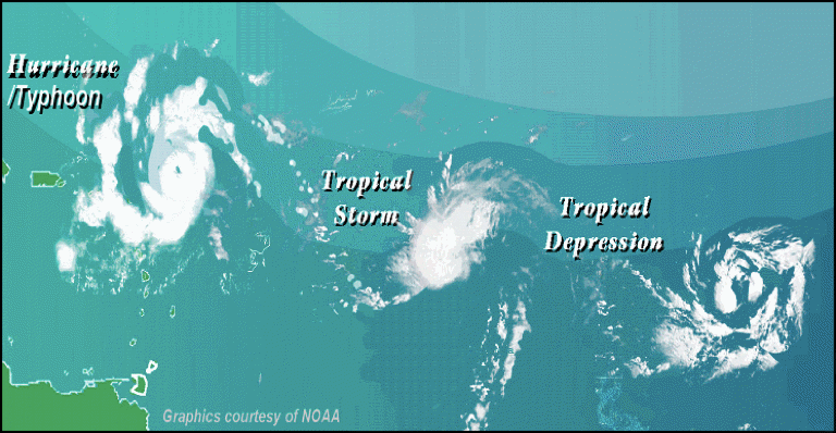
Figure 7: Classification & evolution of a Tropical Cyclone. Graphics Credit by: NOAA
Typhoon Anatomy
A typhoon’s structure are divided into four (4) parts namely: Outer Rainbands, Inner Rainbands, Eyewall, and the Eye (see Fig. 20). Below are the description of each parts.
A typhoon’s structure are divided into four (4) parts namely: Outer Rainbands, Inner Rainbands, Eyewall, and the Eye (see Fig. 20). Below are the description of each parts.
- OUTER RAINBANDS – defined as the outer spiral bands of a typhoon w/c are scattered but moving inward. It is characterized by occasional light to moderate rainfall with winds of up to 62 kph. Heavy squalls of up to 5-minutes occurring every 3 to 6 hours can be expected. Sunlight may still penetrate at these bands (50% cloud cover).
- INNER RAINBANDS – defined as the inner or main spiral bands of a typhoon w/c are now organized & not scattered as it moves inward towards the center. It is characterized by moderate intermittent rains with Tropical Storm Force Winds of 63 to 117 kph. Heavy squalls of up to 5-minutes occurring every hour can be expected. 90% of the sky covered with high to mid-level clouds.
- EYEWALL – an organized band of clouds immediately surrounding the center or “eye” of a typhoon. It is the area of most violent winds, heaviest rainfall & greatest release of heat energy. This “ring” of violent winds & torrential rains is usually 8 to 40 km from the storm’s center or “eye.” Typhoon Force Winds of greater than 118 kph can be expected within this wall.
- EYE – it is here, where the lowest pressure can be found. The relatively calm part of the typhoon with sometimes light winds (of up to 20 kph) blowing. The sky may be just partly cloudy w/ intermittent burst of blue sky through the thin clouds. Average “eye” diameter is about 30 km across.
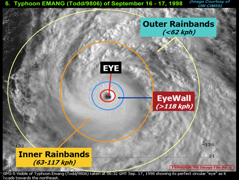
Figure 8: A graphical illustration & satellite view of a Typhoon showing its parts. Image Credit by: University of Wisconsin-CIMSS. Illustration by: David Michael V. Padua.
Reference: http://weather.com.ph//typhoon/climatology
CONCEPT CHECK:
Download and accomplish the work sheet below. Submit using the Assignment Form in the Home Page.
CONCEPT CHECK:
Download and accomplish the work sheet below. Submit using the Assignment Form in the Home Page.
 RSS Feed
